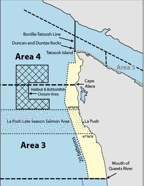
Definition: FROM THE QUEETS RIVER NORTH TO CAPE ALAVA
La Push / Marine Area 3 Salmon Fishing 2024
Every year, the State of Washington represented by WDFW engages with federal regulatory bodies and tribal co-managers to figure out appropriate salmon seasons on stocks of salmon bound for their natal streams.
The process begins in March and culminates towards the end of June as salmon seasons are finalized and communicated to the public.
During this period, one needs to consult emergency regulations more so than permanent regulations for any openers in that time period of March – June. I’ve described this topic extensively in my guide to understanding WDFW saltwater salmon regulations.
Much of the salmon season in Marine Area 3 out of La Push is driven by the Columbia River return forecasts and seasons, but there’s also typically a late season that is more closely tied to salmon returning to rivers in the Forks area via the Quillayute River system.
The late salmon season in La Push / Marine Area 3 will typically have a specific area or bubble where fishing for salmon is allowed.
Typically, a season for salmon in Marine Area 3 will kick off in mid-late June and go until the quota is exhausted. Allowing retention of 2 salmon, 2 of which can be chinook, and a requirement to release wild coho.
Again, the above rules are not the actual current fishing regulations, but to give you an idea if you’re making trip planning decisions.
Chinook retention was reduced to a single fish on June 30th in 2022, which is usually a good indicator that fishing is good in the latter half of June though every year can be different.
A lot of salmon fishing in Marine Area 3 and saltwater locations, in general, is done with downriggers. I’ve written an extensive guide to fishing for salmon with downriggers and also posted a how-to video for beginners to help you get started:
La Push / Marine Area 3 Bottom Fishing
Fishing for a variety of bottom fish out of La Push / Marine Area 3 can be awesome when the season is open.
This typically occurs from the second Sat. in March until the Third Sat. in October. Note: Halibut is different, has special opening days linked below and a quota system.
For both Lingcod and Rockfish, the permanent regulations include several variations in various date periods in terms of depths of fishing which are allowed and rockfish species retention.
For ideas on how to fish for lingcod off Washington coastal waters see this link. Here’s another resource about fishing for lingcod you can use as well.
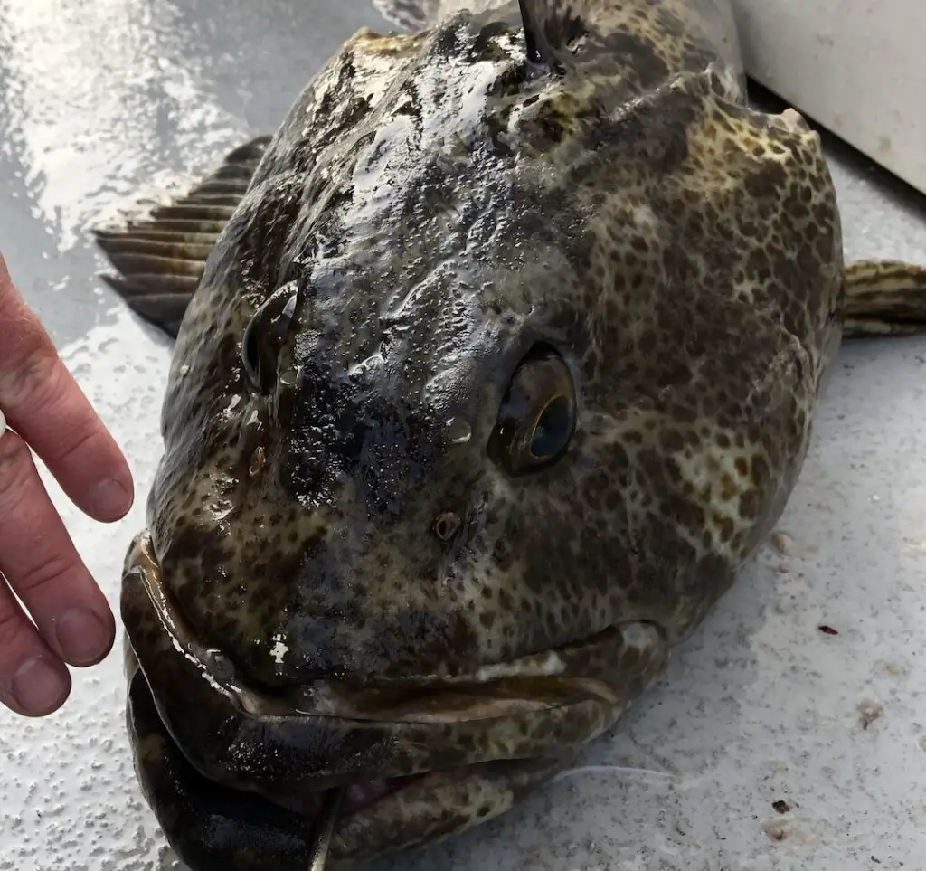
Catching rockfish in our nearshore waters off of the Washington coast provides some of the best and easiest angling opportunities.
Look for any rock piles in water depths typically < 100 ft and you will find significant populations of rockfish.
For help with how to catch rockfish, checkout this link.
The below video was shot in Marine Area 2, but everything in there for targeting lingcod and rockfish applies to Marine Area 3 as well:
Halibut Fishing out of La Push / Marine Area 3
Here’s a link to the WDFW page on halibut fishing in Marine Area 3. It should get updated as seasons and quotas are announced, but there’s a good description of what you can expect if you are trying to make trip-planning decisions.
Staying safe while fishing out of La Push / Marine Area 3
There are some real advantages to making an ocean fishing trip out of La Push when it comes to exiting your point of origin to take on the big open water.
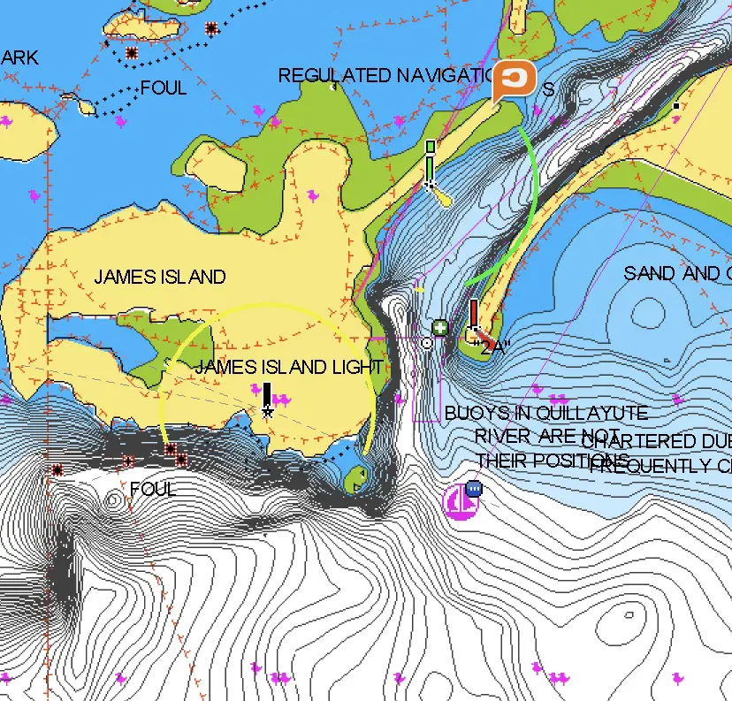
This has everything to do with James Island being an immediate wind stopper from the common west and northwest wind directions that can impact marine boating safety.
Now, what this shouldn’t communicate to you is a lack of risk or a need to pay attention to what’s happening with marine weather in general.
If you get a big wind from the south or southwest which is not infrequent, you’re looking at as difficult a river bar crossing as anywhere on the coast.
Even if you have protection from westerly winds while crossing the bar, if winds are significant, you may still not want to be on the open ocean in those conditions.
I’ve written a page on marine weather safety that’s extensive and one of the best references I’ve found that’s free on the internet, which attempts to explain many of the concepts you need to understand heading over river bars and making trip planning decisions to fish the ocean.
Here’s a video I posted about going over the Westport bar in a smaller boat:
Tides / Marine Forecast for James Island and coastal waters from Cape Flattery to James Island out 10 nm
Please use caution regarding the below information as this feature is new and may encounter bugs that result in inaccurate or stale information being displayed.
Marine Forecast for Coastal Waters From Cape Flattery To James Island Out 10 Nm as of 0 days and 10 hours ago
Forecast published on 03/13/2026 02:50:00 Synopsis: SYNOPSIS FOR THE NORTHERN AND CENTRAL WASHINGTON COASTAL AND INLAND WATERS...A stationary front will remain situated over the southern coastal waters today before moving south of the area on Saturday. High pressure will then build into the coastal waters Saturday and remain situated over the waters on Sunday. A warm front will brush the waters on Monday, bringing the chance for elevated winds and building seas across the coastal waters.
You should always check the forecast on the NWS Marine Forecast Page, the text below is added for your convenience:
Question about how to read a marine forecast to stay safe? Check out our comprehensive guide on Marine Weather Safety here
Yesterday's last tide
| Tide Time (24H) | Predicted (ft) | High-Low | Tide Delta | Avg ft / hour |
| 21:48 | 5.54 ft | H | NA | NA |
03/13/2026 Fri
Hazardous Weather:
Daytime Marine Forecast: NW wind 5 to 10 kt. Seas 6 to 7 ft. Wave Detail: SW 3 ft at 8 seconds and W 6 ft at 11 seconds. Rain likely early this morning, then a chance of rain late this morning. A slight chance of rain thi
| Tide Time (24H) | Predicted (ft) | High-Low | Tide Delta | Avg ft / hour |
| 02:30 | 4.76 ft | L | -0.78 | -0.17 |
| 08:22 | 7.07 ft | H | 2.31 | 0.39 |
| 15:47 | 1.38 ft | L | -5.69 | -0.77 |
| 22:43 | 5.96 ft | H | 4.58 | 0.66 |
03/14/2026 Sat
Daytime Marine Forecast: NW wind 15 to 20 kt. Seas 6 to 8 ft. Wave Detail: W 7 ft at 8 seconds and SW 3 ft at 8 seconds. A chance of rain and snow.| Tide Time (24H) | Predicted (ft) | High-Low | Tide Delta | Avg ft / hour |
| 03:48 | 4.38 ft | L | -1.58 | -0.31 |
| 09:30 | 7.33 ft | H | 2.95 | 0.52 |
| 16:39 | 0.95 ft | L | -6.38 | -0.89 |
| 23:20 | 6.45 ft | H | 5.5 | 0.82 |
03/15/2026 Sun
Daytime Marine Forecast: SE wind 5 to 10 kt, rising to 10 to 15 kt in the afternoon. Seas 3 to 4 ft. Wave Detail: SE 3 ft at 3 seconds, NW 3 ft at 8 seconds and SW 2 ft at 8 seconds. Rain.| Tide Time (24H) | Predicted (ft) | High-Low | Tide Delta | Avg ft / hour |
| 04:45 | 3.76 ft | L | -2.69 | -0.50 |
| 10:27 | 7.70 ft | H | 3.94 | 0.69 |
| 17:21 | 0.56 ft | L | -7.14 | -1.03 |
| 23:51 | 6.98 ft | H | 6.42 | 0.99 |
03/16/2026 Mon
Daytime Marine Forecast: S wind 20 to 25 kt. Seas 8 to 10 ft. Wave Detail: SE 4 ft at 6 seconds and SW 10 ft at 11 seconds. Rain.| Tide Time (24H) | Predicted (ft) | High-Low | Tide Delta | Avg ft / hour |
| 05:31 | 3.01 ft | L | -3.97 | -0.70 |
| 11:17 | 8.04 ft | H | 5.03 | 0.87 |
| 17:58 | 0.28 ft | L | -7.76 | -1.16 |
03/17/2026 Tue
Daytime Marine Forecast: S wind 20 to 25 kt. Seas 10 to 12 ft. Wave Detail: S 4 ft at 6 seconds and SW 12 ft at 12 seconds. Rain.| Tide Time (24H) | Predicted (ft) | High-Low | Tide Delta | Avg ft / hour |
| 00:20 | 7.52 ft | H | 7.24 | 1.14 |
| 06:12 | 2.18 ft | L | -5.34 | -0.91 |
| 12:03 | 8.30 ft | H | 6.12 | 1.05 |
| 18:33 | 0.17 ft | L | -8.13 | -1.25 |
03/18/2026 Wed
| Tide Time (24H) | Predicted (ft) | High-Low | Tide Delta | Avg ft / hour |
| 00:48 | 8.06 ft | H | 7.89 | 1.26 |
| 06:52 | 1.34 ft | L | -6.72 | -1.11 |
| 12:48 | 8.41 ft | H | 7.07 | 1.19 |
Looking for more tides? Checkout the NOAA Tide Prediction page for James Island here
La Push / Marine Area 3 Fishing Regulations
Here’s a link to WDFW’s marine area rules and definitions.
Marine Area permanent regulations are updated in late June / early July of the year as salmon seasons are finalized, and you can access the current Marine Area 3 regulations here.
Emergency Fishing Regulations for La Push / Marine Area 3
The above permanent regulations for Marine Area 3 are subject to change at any time and without being updated on this blog. One must consult the WDFW Emergency Regulations before any trips to ensure they are in full compliance with state laws regulating fisheries.